Le Rocher du diable
27/05/2013
Judith (réceptionniste) et Charly (animateur) ont testé une des randonnées du classeur disponible à l'accueil.
Judith (réceptionniste) et Charly (animateur) ont testé une des randonnées du classeur disponible à l'accueil.
Le choix est tombé sur Le Rocher du Diable pour plusieurs raisons:
- Le point de départ qui est à Arvieu, non loin du camping
- Les boucles de 7,5 km + 8 km : suivant le temps qu'il reste après la première boucle, il est possible d'en faire une deuxième
- Le nom mystérieux, nous incitant à imaginer un rocher diabolique
Et en effet, la randonnée n'a pas été sans danger, mais rien de mieux que la population locale pour y remédier.
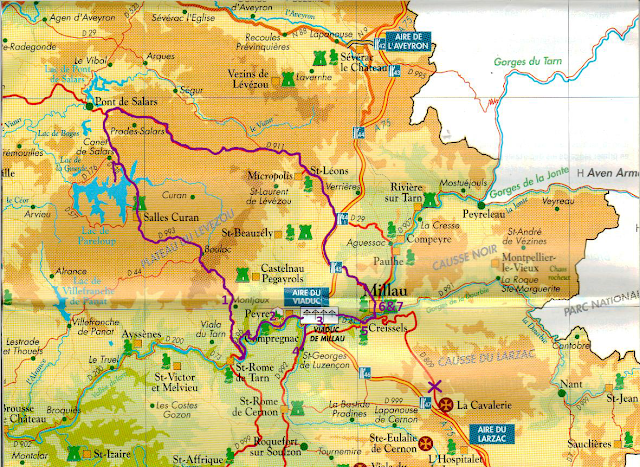
L'éventuel danger: des travaux en cours sur le pont, à côté du point de départ, devant la Mairie, abrité dans un ancien château de 1830. Ceci nous amène à improviser le début de notre randonnée sur base de notre texte et le petit plan.
En passant pas une carrière de Pierre Bleue, nous commençons à douter de notre choix. Le diable doit y être pour quelque chose. De plus, nous n'avons toujours pas vu de balisage jaune.
La cure locale: nous nous sommes adressés à un paysan, qui lui était content de parler à des jeunes venus pour découvrir sa terre. Son voisin va même jusqu'à nous proposer de nous déposer sur le sentier balisé... en 4x4 ! Ainsi nous retrouvons l'itinéraire de notre fiche et nous continuons à pied comme c'était prévu, bravant le relief diabolique... Lors de notre choix nous n'avions pas pris en compte la difficulté de la randonnée**. Deux étoiles ! C'est Judith qui s'en est plaint. Mais pas pour longtemps, maintenant que nous nous trouvons sur la bonne route, le paysage a changé... en bien!
Au bout de quelques minutes de marche, nous voyons au loin notre paysan avec son troupeau de moutons. Charly décide de prendre une photo afin d'immortaliser cette rencontre.
Après toutes les interventions diaboliques, le rocher s'avère plutôt décevant : pas de gros rocher impressionnant. La différence entre le début où nous n'étions pas sur la bonne route et la randonnée est facile à distinguer : ici, tous les deux pas un panneau explicatif sur la faune et la flore. Le balisage, ou plutôt le repérage de balisage devenait, pour nous, très vite un jeu. Qui c'est qui va trouver en premier le bandeau jaune ?
Finalement, nous avons trouvé la balade un peu court, mais l'après-midi était déjà trop avancé pour faire la deuxième boucle. Si nous avions su, nous nous serions arrêtés sur un de nombreux herbeux pour se poser avec un livre ou un pique-nique. Nous avons aussi particulièrement apprécié le contact avec la population locale et leur envie de partager la beauté de leurs terres. A conseiller !
27/05/2013
Judith (receptionist) and Charly (animator) from Le Caussanel tested one of the walks available at reception.
We settled on The Devil's Rock route for multiple reasons
1. The departure point is in Arvieu, not far from the campsite
2. There are 2 circuits of 7.5km and 8km: depending on the time remaining after the first circuit, it's possible to try out the second
3. The mysterious name, making us imagine a diabolic rock
And, in actual fact, the walk did entail a certain element of danger, but nothing better than the locals to help us find a solution!
The possible danger: road works taking place on the bridge alongside our departure point, in front of the Mairie (town hall) which is housed in an old castle from 1830. This leads us to improvise the start of our walk based on our text and little map. Passing by a Pierre Bleue quarry, we begin to doubt whether we were right to improvise. The devil must have had a hand in this! What's more, we still haven't seen the yellow indications.
The local cure: we ask a farmer for help, he's more than happy to talk to some young people here to discover his territory. His neighbour even offers to drop us off on the correct route... in his 4x4! Finally we recover our sheet's planned route and continue on foot as directed, braving the diabolic incline... During our selection we hadn't taken into account the difficulty rating of the walk **: two stars!! It's Judith who's the first to grumble. But not for long, now that we find ourselves on the correct route, the scenery starts to change... and what a view!
After some minutes of walking, we see from afar our farmer with his flock of sheep. Charly decides to take a photo of the scene to immortalise the meeting.
After all these diabolic interventions, the rock itself appears a little deceiving: not at all the great, impressive rock we were expecting. The difference between the beginning when we were on the incorrect path and the route we are now following is easy to distinguisg: here every two steps you come across an informative sign about the fauna and flora of the surrounding area.
The sign posts, or rather the spotting of the sign posts very quickly becomes a game for us.
Who will be the first to find the yellow stripes?
In summary: we found the walk a little bit too short, but it was already too far in to the afternoon to do the second circuit. If we had known, we would have stopped on one of the numerous grassy spots to lie down with a book or have a picnic. We also particularly appreciated the contact with the local people and their eagerness to share the beauty of their lands. Definitely recommended!
27/05/2013
Judith (receptionniste) en Charly (animator) hebben een wandeling getest uit de map beschikbaar aan het onthaal.
We hebben De Duivelrots gekozen voor meerdere redenen:
- Het vertrekpunt omdat het in Arvieu ligt, niet ver van de camping
- De mogelijkheden, twee lussen 7,5 km + 8 km: als er nog tijd over is na de eerste lus, kan je beslissen om ook de tweede te doen
- De mysterieuze naam, omdat die onze verbeelding prikkelt
We ontdekken al gauw dat deze wandeling niet zonder gevaar is, maar er is niets beters dan de lokale bevolking om de vloek op te heffen.
Het eventuele gevaar (de vloek): werken op de brug, vlakbij het vertrekpunt voor het stadhuis, een kasteel daterend uit 1830. Door dit oponthoud moeten we het begin van de wandeling improviseren op basis van ons tekstje met plannetje.
Zodra we langs een steengroeve van blauwsteen lopen, beginnen we te twijfelen of we wel goed geïmproviseerd hebben. De Duivel moet er voor iets tussen zitten, want we hebben ook nog steeds geen gele aanduiding gezien.
De vloekopheffing: we vragen aan een boer of hij ons kan helpen en zijn buurman die ons gesprek oppikt, stelt meteen voor om ons opnieuw op de juiste weg te zetten... met zijn 4x4! Zo belanden we uiteindelijke toch op de uitgestippelde wandeling en we zetten de tocht verder te voet, zoals voorzien, het duivelse reliëf trotserend... Toen we onze keuze hebben gemaakt, hebben we namelijk geen rekening gehouden met de moeilijkheidsgraad van de wandeling**: twee sterren!! Daar was Judith niet zo blij mee, maar dat duurde niet lang want al snel worden we afgeleid door het landschap. Dat is eens wat anders dan een luidruchtige steengroeve.
Na enkele minuten zien we in de verte onze redder met zijn schapen. Charly haalt zijn fototoestel boven om onze ontmoeting vast te leggen.
Na alle duivelse tussenkomsten, is de duivelrots zelf eerder teleurstellend: niet groot en nogal onopvallend. Het verschil tussen onze in het begin geïmproviseerde wandeling en de eigenlijke wandeling wordt snel duidelijk: hier vindt u om de paar meter een bord met uitleg over de fauna en flora.
De wegaanduiding is niet echt logisch en al gauw wordt het een spelletje wie heeft het eerst de gele band gezien die aanduidt dat we nog steeds op het juiste pad lopen?
Uiteindelijk vonden we de wandeling iets te kort, maar de namiddag was al te ver gevorderd om de tweede lus te testen.
Als we hadden geweten dat het zo kort zou zijn, dan waren we zeker op één van de grasvelden blijven zitten om een boek te lezen of om van een pick nick te genieten. Wat we ook fantastisch vonden aan onze uitstap: het contact met de dorpsbewoners en hun passie voor hun streek. Dit is een aanrader, dat de duivel het u gezegd heeft!
Commentaires